
Make a donation
Gear up for your next adventure:
As an Amazon Associate, this site earns from qualifying purchases at no extra cost to you.
Zagreb topographic map
Click on the map to display elevation.
Make a donation
Gear up for your next adventure:
As an Amazon Associate, this site earns from qualifying purchases at no extra cost to you.
Zagreb
Zagreb (/ˈzɑːɡrɛb, ˈzæɡrɛb, zɑːˈɡrɛb/ ZAH-greb, ZAG-reb, zah-GREB, Croatian: [zǎːɡreb] (listen)) is the capital and largest city of Croatia. It is in the northwest of the country, along the Sava river, at the southern slopes of the Medvednica mountain. Zagreb stands near the international border between Croatia and Slovenia at an elevation of approximately 122 m (400 ft) above sea level. At the 2021 census, the city had a population of 767,131. The population of the Zagreb urban agglomeration is 1,071,150, approximately a quarter of the total population of Croatia.
Make a donation
Gear up for your next adventure:
As an Amazon Associate, this site earns from qualifying purchases at no extra cost to you.
About this map
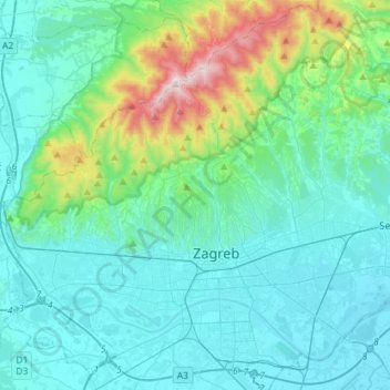
Name: Zagreb topographic map, elevation, terrain.
Location: Zagreb, City of Zagreb, Croatia (45.74600 15.82171 45.93930 16.10701)
Average elevation: 817 ft
Minimum elevation: 328 ft
Maximum elevation: 3,353 ft
Make a donation
Gear up for your next adventure:
As an Amazon Associate, this site earns from qualifying purchases at no extra cost to you.
Other topographic maps
Click on a map to view its topography, its elevation and its terrain.