
Make a donation
Gear up for your next adventure:
As an Amazon Associate, this site earns from qualifying purchases at no extra cost to you.
Horna topographic map
Click on the map to display elevation.
Make a donation
Gear up for your next adventure:
As an Amazon Associate, this site earns from qualifying purchases at no extra cost to you.
Horna
En las inmediaciones del pueblo se encuentra el nacimiento del río Henares, afluente del Jarama. La altitud de los distintos terrenos sobre el nivel del mar varía entre 1271 m y 1064 m siendo la altitud media del término igual a 1116 m. La superficie del término municipal es de 1912 ha y el perímetro es de 20 500 m. Las tierras que conforman el municipio separan las cuencas hidrográficas del Duero y el Tajo, quedando ubicadas todas ellas en la vertiente del Tajo.
Make a donation
Gear up for your next adventure:
As an Amazon Associate, this site earns from qualifying purchases at no extra cost to you.
About this map
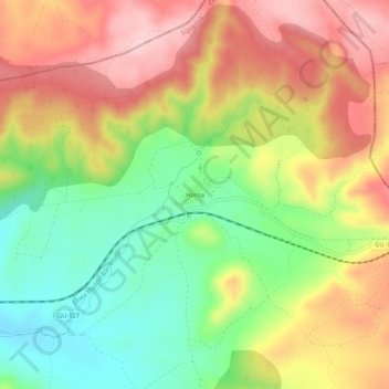
Name: Horna topographic map, elevation, terrain.
Location: Horna, Sigüenza, Guadalajara, Castilla-La Mancha, España (41.11310 -2.56126 41.15310 -2.52126)
Average elevation: 3,711 ft
Minimum elevation: 3,366 ft
Maximum elevation: 4,065 ft
Make a donation
Gear up for your next adventure:
As an Amazon Associate, this site earns from qualifying purchases at no extra cost to you.
Other topographic maps
Click on a map to view its topography, its elevation and its terrain.