
Make a donation
Gear up for your next adventure:
As an Amazon Associate, this site earns from qualifying purchases at no extra cost to you.
Amber Lake topographic map
Click on the map to display elevation.
Make a donation
Gear up for your next adventure:
As an Amazon Associate, this site earns from qualifying purchases at no extra cost to you.
About this map
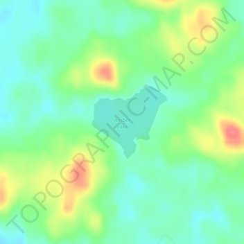
Name: Amber Lake topographic map, elevation, terrain.
Location: Amber Lake, Saint Lawrence County, New York, United States (44.39470 -74.62531 44.40276 -74.61359)
Average elevation: 1,565 ft
Minimum elevation: 1,490 ft
Maximum elevation: 1,706 ft
Saint Lawrence County trails, hiking, mountain biking, running and outdoor activities
Make a donation
Gear up for your next adventure:
As an Amazon Associate, this site earns from qualifying purchases at no extra cost to you.
Other topographic maps
Click on a map to view its topography, its elevation and its terrain.
Make a donation
Gear up for your next adventure:
As an Amazon Associate, this site earns from qualifying purchases at no extra cost to you.
DeKalb Junction
United States > New York > Saint Lawrence County > Town of De Kalb
Average elevation: 430 ft
Village of Rensselaer Falls
United States > New York > Saint Lawrence County > Town of Canton
Average elevation: 322 ft
Star Lake
United States > New York > Saint Lawrence County > Town of Fine > Star Lake
Average elevation: 1,453 ft
Town of Hammond
United States > New York > Saint Lawrence County > Town of Hammond
The Village of Hammond is located at 44°26′56″N 75°41′39″W / 44.44889°N 75.69417°W / 44.44889; -75.69417Coordinates: 44°26′56″N 75°41′39″W / 44.44889°N 75.69417°W / 44.44889; -75.69417. The elevation is 358 feet (109 m).
Average elevation: 325 ft
Make a donation
Gear up for your next adventure:
As an Amazon Associate, this site earns from qualifying purchases at no extra cost to you.
Cedar Island State Park
United States > New York > Saint Lawrence County > Town of Hammond
Average elevation: 243 ft
Make a donation
Gear up for your next adventure:
As an Amazon Associate, this site earns from qualifying purchases at no extra cost to you.
Make a donation
Gear up for your next adventure:
As an Amazon Associate, this site earns from qualifying purchases at no extra cost to you.
Village of Hammond
United States > New York > Saint Lawrence County > Village of Hammond
Average elevation: 358 ft
Brasher Falls
United States > New York > Saint Lawrence County > Brasher Falls
Average elevation: 315 ft
Make a donation
Gear up for your next adventure:
As an Amazon Associate, this site earns from qualifying purchases at no extra cost to you.