Make a donation
Gear up for your next adventure:
As an Amazon Associate, this site earns from qualifying purchases at no extra cost to you.
Rechenberg topographic map
Click on the map to display elevation.
Make a donation
Gear up for your next adventure:
As an Amazon Associate, this site earns from qualifying purchases at no extra cost to you.
Rechenberg
Der Rechenberg liegt im Nordosten Nürnbergs im Stadtteil St. Jobst, nördlich der Äußeren Sulzbacher Straße. Er erstreckt sich in Ost-West-Richtung und hat eine Größe von 5,6 ha. Seinen Mittelpunkt bildet der namensgebende „Rechenberg“, ein Höhenrücken aus Burgsandstein (ca. 338 m ü. NHN). Er ist die zweithöchste Erhebung im Stadtgebiet von Nürnberg.
Make a donation
Gear up for your next adventure:
As an Amazon Associate, this site earns from qualifying purchases at no extra cost to you.
About this map
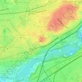
Name: Rechenberg topographic map, elevation, terrain.
Location: Rechenberg, Nürnberg, Bayern, 90491, Deutschland (49.46346 11.11061 49.46356 11.11071)
Average elevation: 1,047 ft
Minimum elevation: 968 ft
Maximum elevation: 1,125 ft
Make a donation
Gear up for your next adventure:
As an Amazon Associate, this site earns from qualifying purchases at no extra cost to you.
Other topographic maps
Click on a map to view its topography, its elevation and its terrain.
Make a donation
Gear up for your next adventure:
As an Amazon Associate, this site earns from qualifying purchases at no extra cost to you.
Make a donation
Gear up for your next adventure:
As an Amazon Associate, this site earns from qualifying purchases at no extra cost to you.
Make a donation
Gear up for your next adventure:
As an Amazon Associate, this site earns from qualifying purchases at no extra cost to you.
