
Macari topographic map
Interactive map
Click on the map to display elevation.
About this map
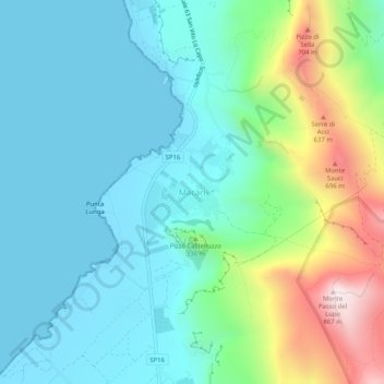
Name: Macari topographic map, elevation, terrain.
Location: Macari, San Vito Lo Capo, Trapani, Sicile, 91010, Italie (38.11172 12.71904 38.15172 12.75904)
Average elevation: 666 ft
Minimum elevation: -3 ft
Maximum elevation: 2,792 ft
Other topographic maps
Click on a map to view its topography, its elevation and its terrain.
San Vito Lo Capo
San Vito Lo Capo, Trapani, Sicile, 91010, Italie
Average elevation: 512 ft
Îles Égades
Italie > Sicile > Trapani > Favignana
Îles Égades, Favignana, Trapani, Sicile, 91023, Italie
Average elevation: 7 ft
Castellammare del Golfo
Italie > Sicile > Trapani > Castellammare del Golfo
Castellammare del Golfo, Trapani, Sicile, 91014, Italie
Average elevation: 827 ft
Pantelleria
Pantelleria, Trapani, Sicile, 91017, Italie
Average elevation: 272 ft
Cortigliolo
Italie > Sicile > Trapani > Valderice
Cortigliolo, Valderice, Trapani, Sicile, 91019, Italie
Average elevation: 128 ft