
Badghis topographic map
Interactive map
Click on the map to display elevation.
About this map
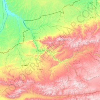
Name: Badghis topographic map, elevation, terrain.
Location: Badghis, Afghanistan (34.51324 62.66560 36.03633 65.06914)
Average elevation: 4,790 ft
Minimum elevation: 1,053 ft
Maximum elevation: 11,411 ft
Other topographic maps
Click on a map to view its topography, its elevation and its terrain.
Darreh-ye Galleh Cheshmeh;Darrah-i-Gala Casma;Darah-ye Galah Chashmah
Darreh-ye Galleh Cheshmeh;Darrah-i-Gala Casma;Darah-ye Galah Chashmah, Murghab, Badghis, Afghanistan
Average elevation: 2,677 ft