
Make a donation
Gear up for your next adventure:
As an Amazon Associate, this site earns from qualifying purchases at no extra cost to you.
Altavilla topographic map
Click on the map to display elevation.
Make a donation
Gear up for your next adventure:
As an Amazon Associate, this site earns from qualifying purchases at no extra cost to you.
Altavilla
Altavilla è una frazione del comune di Lappano, nella provincia di Cosenza, Calabria, Italia. Il centro abitato è arroccato su un colle della Presila cosentina. Il paese, di 171 abitanti, si trova ad un'altitudine di 668 m s.l.m.
Make a donation
Gear up for your next adventure:
As an Amazon Associate, this site earns from qualifying purchases at no extra cost to you.
About this map
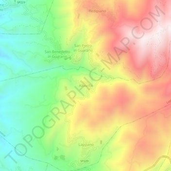
Name: Altavilla topographic map, elevation, terrain.
Location: Altavilla, Lappano, Cosenza, Calabria, 87047, Italia (39.31326 16.29203 39.35326 16.33203)
Average elevation: 2,156 ft
Minimum elevation: 919 ft
Maximum elevation: 3,488 ft
Make a donation
Gear up for your next adventure:
As an Amazon Associate, this site earns from qualifying purchases at no extra cost to you.