
Thank you for supporting this site ❤️
Make a donation
Make a donation
Gear up for your next adventure:
As an Amazon Associate, this site earns from qualifying purchases at no extra cost to you.
uMngwenya topographic map
Click on the map to display elevation.
Thank you for supporting this site ❤️
Make a donation
Make a donation
Gear up for your next adventure:
As an Amazon Associate, this site earns from qualifying purchases at no extra cost to you.
About this map
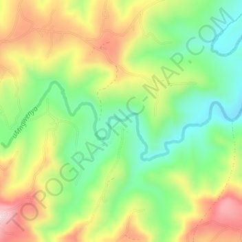
Name: uMngwenya topographic map, elevation, terrain.
Average elevation: 1,437 ft
Minimum elevation: 968 ft
Maximum elevation: 2,047 ft
Thank you for supporting this site ❤️
Make a donation
Make a donation
Gear up for your next adventure:
As an Amazon Associate, this site earns from qualifying purchases at no extra cost to you.
Other topographic maps
Click on a map to view its topography, its elevation and its terrain.
Gingindlovu
South Africa > KwaZulu-Natal > King Cetswayo District Municipality > uMlalazi Local Municipality
Average elevation: 217 ft