
Make a donation
Gear up for your next adventure:
As an Amazon Associate, this site earns from qualifying purchases at no extra cost to you.
Loggerheads topographic map
Click on the map to display elevation.
Make a donation
Gear up for your next adventure:
As an Amazon Associate, this site earns from qualifying purchases at no extra cost to you.
About this map
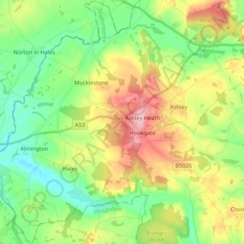
Name: Loggerheads topographic map, elevation, terrain.
Average elevation: 453 ft
Minimum elevation: 253 ft
Maximum elevation: 787 ft
Make a donation
Gear up for your next adventure:
As an Amazon Associate, this site earns from qualifying purchases at no extra cost to you.
Other topographic maps
Click on a map to view its topography, its elevation and its terrain.
College Gardens
United Kingdom > England > Staffordshire > Newcastle-under-Lyme > Madeley
Average elevation: 404 ft
Wain Lea
United Kingdom > England > Staffordshire > Newcastle-under-Lyme > Harriseahead
Average elevation: 679 ft
Apedale
United Kingdom > England > Staffordshire > Newcastle-under-Lyme > Chesterton
Average elevation: 551 ft
Make a donation
Gear up for your next adventure:
As an Amazon Associate, this site earns from qualifying purchases at no extra cost to you.
Newcastle-under-Lyme
United Kingdom > England > Staffordshire > Newcastle-under-Lyme
Average elevation: 482 ft
Bignall End
United Kingdom > England > Staffordshire > Newcastle-under-Lyme > Audley
Average elevation: 492 ft
Wood Lane
United Kingdom > England > Staffordshire > Newcastle-under-Lyme > Bignall Hill
Average elevation: 551 ft
Make a donation
Gear up for your next adventure:
As an Amazon Associate, this site earns from qualifying purchases at no extra cost to you.
Whitmore Heath
United Kingdom > England > Staffordshire > Newcastle-under-Lyme > Whitmore
Average elevation: 463 ft
Make a donation
Gear up for your next adventure:
As an Amazon Associate, this site earns from qualifying purchases at no extra cost to you.
Birks Wood
United Kingdom > England > Staffordshire > Newcastle-under-Lyme > Shraleybrook
Average elevation: 358 ft
Burgess Brook
United Kingdom > England > Staffordshire > Newcastle-under-Lyme
Average elevation: 489 ft
The Brampton
United Kingdom > England > Staffordshire > Newcastle-under-Lyme
Average elevation: 459 ft
Make a donation
Gear up for your next adventure:
As an Amazon Associate, this site earns from qualifying purchases at no extra cost to you.
Harriseahead
United Kingdom > England > Staffordshire > Newcastle-under-Lyme
Average elevation: 656 ft
Talke Pits
United Kingdom > England > Staffordshire > Newcastle-under-Lyme > Talke
Average elevation: 587 ft
Make a donation
Gear up for your next adventure:
As an Amazon Associate, this site earns from qualifying purchases at no extra cost to you.
Blore
United Kingdom > England > Staffordshire > Newcastle-under-Lyme > Loggerheads
Average elevation: 449 ft
Ashley Dale
United Kingdom > England > Staffordshire > Newcastle-under-Lyme > Loggerheads
Average elevation: 564 ft
Barhill
United Kingdom > England > Staffordshire > Newcastle-under-Lyme > Madeley
Average elevation: 400 ft
The Moss
United Kingdom > England > Staffordshire > Newcastle-under-Lyme > Madeley
Average elevation: 400 ft
Make a donation
Gear up for your next adventure:
As an Amazon Associate, this site earns from qualifying purchases at no extra cost to you.
Chapel Chorlton
United Kingdom > England > Staffordshire > Newcastle-under-Lyme
Average elevation: 436 ft
Red Bull
United Kingdom > England > Staffordshire > Newcastle-under-Lyme > Loggerheads
Average elevation: 361 ft
Dunkirk
United Kingdom > England > Staffordshire > Newcastle-under-Lyme > Talke > Dunkirk
Average elevation: 489 ft
Make a donation
Gear up for your next adventure:
As an Amazon Associate, this site earns from qualifying purchases at no extra cost to you.
Madeley Heath
United Kingdom > England > Staffordshire > Newcastle-under-Lyme
Average elevation: 456 ft
Ashley Heath
United Kingdom > England > Staffordshire > Newcastle-under-Lyme
Average elevation: 630 ft