
Thank you for supporting this site ❤️
Make a donation
Make a donation
Gear up for your next adventure:
As an Amazon Associate, this site earns from qualifying purchases at no extra cost to you.
Amorosa topographic map
Click on the map to display elevation.
Thank you for supporting this site ❤️
Make a donation
Make a donation
Gear up for your next adventure:
As an Amazon Associate, this site earns from qualifying purchases at no extra cost to you.
About this map
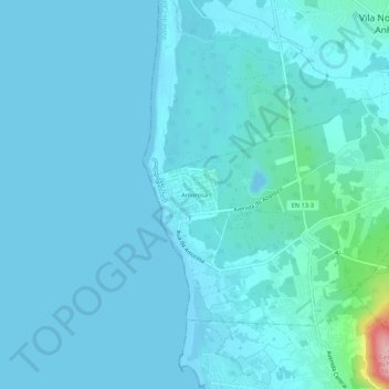
Name: Amorosa topographic map, elevation, terrain.
Location: Amorosa, Chafé, Viana do Castelo, 4935-580, Portugal (41.62620 -8.84014 41.66620 -8.80014)
Average elevation: 46 ft
Minimum elevation: -7 ft
Maximum elevation: 577 ft
Thank you for supporting this site ❤️
Make a donation
Make a donation
Gear up for your next adventure:
As an Amazon Associate, this site earns from qualifying purchases at no extra cost to you.
Other topographic maps
Click on a map to view its topography, its elevation and its terrain.
Praia de Amorosa
Portugal > Viana do Castelo > Viana do Castelo > Chafé > Amorosa
Average elevation: 26 ft