
Thank you for supporting this site ❤️
Make a donation
Make a donation
Gear up for your next adventure:
As an Amazon Associate, this site earns from qualifying purchases at no extra cost to you.
Almendrón topographic map
Click on the map to display elevation.
Thank you for supporting this site ❤️
Make a donation
Make a donation
Gear up for your next adventure:
As an Amazon Associate, this site earns from qualifying purchases at no extra cost to you.
About this map
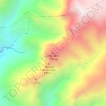
Name: Almendrón topographic map, elevation, terrain.
Location: Almendrón, Nerja, La Axarquía, Málaga, Andalucía, España (36.82548 -3.83995 36.82558 -3.83985)
Average elevation: 3,527 ft
Minimum elevation: 1,657 ft
Maximum elevation: 5,531 ft
Thank you for supporting this site ❤️
Make a donation
Make a donation
Gear up for your next adventure:
As an Amazon Associate, this site earns from qualifying purchases at no extra cost to you.
Other topographic maps
Click on a map to view its topography, its elevation and its terrain.
Paraje Natural Acantilados de Maro-Cerro Gordo
España > Andalucía > La Axarquía > Nerja
Average elevation: 276 ft