
Thank you for supporting this site ❤️
Make a donation
Make a donation
Gear up for your next adventure:
As an Amazon Associate, this site earns from qualifying purchases at no extra cost to you.
Hartberg topographic map
Click on the map to display elevation.
Thank you for supporting this site ❤️
Make a donation
Make a donation
Gear up for your next adventure:
As an Amazon Associate, this site earns from qualifying purchases at no extra cost to you.
About this map
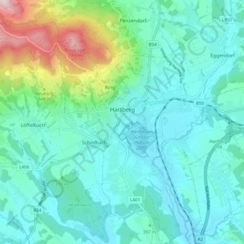
Name: Hartberg topographic map, elevation, terrain.
Location: Hartberg, Bezirk Hartberg-Fürstenfeld, Styria, 8230, Austria (47.24609 15.94411 47.30904 16.02669)
Average elevation: 1,342 ft
Minimum elevation: 1,014 ft
Maximum elevation: 2,700 ft
Thank you for supporting this site ❤️
Make a donation
Make a donation
Gear up for your next adventure:
As an Amazon Associate, this site earns from qualifying purchases at no extra cost to you.