
Thank you for supporting this site ❤️
Make a donation
Make a donation
Gear up for your next adventure:
As an Amazon Associate, this site earns from qualifying purchases at no extra cost to you.
Monchy topographic map
Click on the map to display elevation.
Thank you for supporting this site ❤️
Make a donation
Make a donation
Gear up for your next adventure:
As an Amazon Associate, this site earns from qualifying purchases at no extra cost to you.
About this map
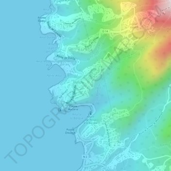
Name: Monchy topographic map, elevation, terrain.
Location: Monchy, Bouillante, Basse-Terre, Guadeloupe, 97125, France (16.08378 -61.77730 16.10378 -61.75730)
Average elevation: 272 ft
Minimum elevation: 0 ft
Maximum elevation: 1,621 ft
Thank you for supporting this site ❤️
Make a donation
Make a donation
Gear up for your next adventure:
As an Amazon Associate, this site earns from qualifying purchases at no extra cost to you.