Geolocate

Talisay topographic map

Click on the map to display elevation.

About this map

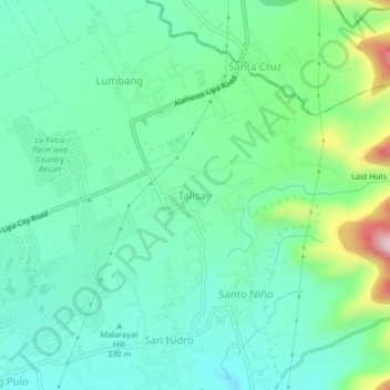
Name: Talisay topographic map, elevation, terrain.

Location: Talisay, Lipa, Batangas, Calabarzon, Philippines (13.95136 121.18702 13.99136 121.22702)

Average elevation: 1,191 ft

Minimum elevation: 873 ft

Maximum elevation: 2,149 ft

Other topographic maps

Click on a map to view its topography, its elevation and its terrain.

Sabang

Philippines > Batangas > Lipa

Average elevation: 1,063 ft

Tambo

Philippines > Batangas > Lipa

Average elevation: 1,158 ft

6

Philippines > Batangas > Lipa

Average elevation: 1,027 ft

Lipa City Community Park

Philippines > Batangas > Lipa > Latag

Average elevation: 1,020 ft

Malepunyo Mountain Range

Philippines > Batangas > Lipa

Average elevation: 968 ft

Pangao

Philippines > Batangas > Lipa

Average elevation: 1,063 ft

Pinagkawitan

Philippines > Batangas > Lipa

Average elevation: 732 ft

Pangao

Philippines > Batangas > Lipa

Average elevation: 1,063 ft

Sabang

Philippines > Batangas > Lipa

Average elevation: 1,063 ft

Lumbang

Philippines > Batangas > Lipa

Average elevation: 1,138 ft

Halang

Philippines > Batangas > Lipa > Halang

Average elevation: 561 ft

Gear up for your next adventure:

🦶Carbon Trekking Poles - Reduce knee impact on steep descents with ultra-light poles
🧣Merino Neck Gaiters - Multi-functional headwear for wind and sun protection
🔌Solar Panel Charger - Charge gear sustainably outdoors
🔦Powerful Headlamps - Ultra-bright hands-free lighting for night navigation
🧥Men's Rain Shells - Premium waterproof and breathable jackets for mountain weather

As an Amazon Associate, this site earns from qualifying purchases at no extra cost to you.