
Make a donation
Gear up for your next adventure:
As an Amazon Associate, this site earns from qualifying purchases at no extra cost to you.
Jocotitlán topographic map
Click on the map to display elevation.
Make a donation
Gear up for your next adventure:
As an Amazon Associate, this site earns from qualifying purchases at no extra cost to you.
Jocotitlán
The municipality is located between Ixtlahuaca and Atlacomulco, fifty four kilometers north of the state capital of Toluca. This area is in the northwest of the state, in the Ixtlahuaca Valley, which is formed by small mountain chains that belong to the Sierra Madre Occidental, with some formations as a result of being on the Trans-Mexican Volcanic Belt. Elevation varies from 2,530 masl next to the Lerma River on the far south to 2,900, on one side of the Jocotitlán volcano, with an average of 2,770. However, much of the land in the area is relatively flat and covers much of the Ixtlahuaca Valley. The municipal seat is on the side of the volcano, with the rest of the municipality on the valley floor. Other elevations include hills in San Miguel Tenochtitlán, and Santiago Casandeje.
Make a donation
Gear up for your next adventure:
As an Amazon Associate, this site earns from qualifying purchases at no extra cost to you.
About this map
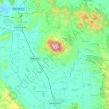
Name: Jocotitlán topographic map, elevation, terrain.
Location: Jocotitlán, State of Mexico, Mexico (19.61394 -100.01571 19.81729 -99.65888)
Average elevation: 8,773 ft
Minimum elevation: 8,045 ft
Maximum elevation: 12,789 ft
Make a donation
Gear up for your next adventure:
As an Amazon Associate, this site earns from qualifying purchases at no extra cost to you.