Geolocate

Kandi topographic map

Click on the map to display elevation.

About this map

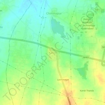
Name: Kandi topographic map, elevation, terrain.

Location: Kandi, Kandi mandal, Sangareddy, Telangana, 502285, India (17.56127 78.08845 17.60127 78.12845)

Average elevation: 1,736 ft

Minimum elevation: 1,683 ft

Maximum elevation: 1,795 ft

Gear up for your next adventure:

👖Convertible Hiking Pants - Versatile zip-off pants for changing altitudes and temperatures
🏕️Tent Footprint - Protect your tent base from wear
📷Action Camera - Capture your outdoor adventures in HD
🔋Rechargeable Batteries - Power up your outdoor devices
🛠️Backpacking Tool Kit - Essential toolkit for outdoor repairs

As an Amazon Associate, this site earns from qualifying purchases at no extra cost to you.