
Thank you for supporting this site ❤️
Make a donation
Make a donation
Gear up for your next adventure:
As an Amazon Associate, this site earns from qualifying purchases at no extra cost to you.
Pampaneira topographic map
Click on the map to display elevation.
Thank you for supporting this site ❤️
Make a donation
Make a donation
Gear up for your next adventure:
As an Amazon Associate, this site earns from qualifying purchases at no extra cost to you.
About this map
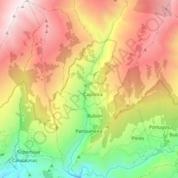
Name: Pampaneira topographic map, elevation, terrain.
Average elevation: 5,719 ft
Minimum elevation: 1,736 ft
Maximum elevation: 10,098 ft
Thank you for supporting this site ❤️
Make a donation
Make a donation
Gear up for your next adventure:
As an Amazon Associate, this site earns from qualifying purchases at no extra cost to you.
Other topographic maps
Click on a map to view its topography, its elevation and its terrain.
Sierra Nevada
Spain > Andalusia > Comarca de la Alpujarra Granadina > Lanjarón
Average elevation: 7,293 ft
Mecina Bombarón
Spain > Andalusia > Comarca de la Alpujarra Granadina > Alpujarra de la Sierra
Average elevation: 4,239 ft