
Thank you for supporting this site ❤️
Make a donation
Make a donation
Gear up for your next adventure:
As an Amazon Associate, this site earns from qualifying purchases at no extra cost to you.
Betesa topographic map
Click on the map to display elevation.
Thank you for supporting this site ❤️
Make a donation
Make a donation
Gear up for your next adventure:
As an Amazon Associate, this site earns from qualifying purchases at no extra cost to you.
About this map
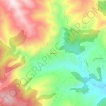
Name: Betesa topographic map, elevation, terrain.
Location: Betesa, Arén, Ribagorza, Huesca, Aragón, España (42.33255 0.67183 42.37255 0.71183)
Average elevation: 3,957 ft
Minimum elevation: 2,815 ft
Maximum elevation: 5,246 ft
Thank you for supporting this site ❤️
Make a donation
Make a donation
Gear up for your next adventure:
As an Amazon Associate, this site earns from qualifying purchases at no extra cost to you.