Geolocate

Tool topographic map

Click on the map to display elevation.

About this map

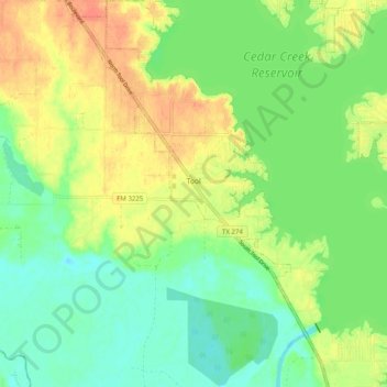
Name: Tool topographic map, elevation, terrain.

Location: Tool, Henderson County, Texas, United States (32.22697 -96.20456 32.31165 -96.13837)

Average elevation: 325 ft

Minimum elevation: 266 ft

Maximum elevation: 397 ft

Henderson County trails, hiking, mountain biking, running and outdoor activities

Other topographic maps

Click on a map to view its topography, its elevation and its terrain.

Lake Palestine

United States > Texas > Henderson County > Chandler

Average elevation: 367 ft

LaRue

United States > Texas > Henderson County

Average elevation: 489 ft

Murchison

United States > Texas > Henderson County

Average elevation: 479 ft

Gear up for your next adventure:

🗺️Topographic Maps - Detailed topo maps for hiking, exploring and outdoor navigation
🪑Ultralight Camp Chairs - Portable seating for resting after a long day of mapping
🪓Survival Multi‑Tool - Versatile tool for camp and trail tasks
🗃️Trail First Aid Kit - Essential kit for outdoor injuries and emergencies
🥾Women's Hiking Boots - Top-rated trail boots with ankle support and superior grip

As an Amazon Associate, this site earns from qualifying purchases at no extra cost to you.