
Make a donation
Gear up for your next adventure:
As an Amazon Associate, this site earns from qualifying purchases at no extra cost to you.
Oederan topographic map
Click on the map to display elevation.
Make a donation
Gear up for your next adventure:
As an Amazon Associate, this site earns from qualifying purchases at no extra cost to you.
Oederan
Auf der Udohöhe bei Schönerstadt (496 m NN) wurde in den 1860er-Jahren eine Station 1. Ordnung der Königlich-Sächsischen Triangulation, eine Vermessungssäule errichtet, die noch heute vorhanden ist.
Make a donation
Gear up for your next adventure:
As an Amazon Associate, this site earns from qualifying purchases at no extra cost to you.
About this map
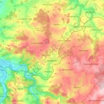
Name: Oederan topographic map, elevation, terrain.
Location: Oederan, Mittelsachsen, Sachsen, 09569, Deutschland (50.81049 13.11975 50.93234 13.25374)
Average elevation: 1,352 ft
Minimum elevation: 883 ft
Maximum elevation: 1,811 ft
Make a donation
Gear up for your next adventure:
As an Amazon Associate, this site earns from qualifying purchases at no extra cost to you.