
Make a donation
Gear up for your next adventure:
As an Amazon Associate, this site earns from qualifying purchases at no extra cost to you.
Pottenstein topographic map
Click on the map to display elevation.
Make a donation
Gear up for your next adventure:
As an Amazon Associate, this site earns from qualifying purchases at no extra cost to you.
Pottenstein
The city of Pottenstein, altitude 350–614 m AMSL, with its nearly 1,500 inhabitants, is a health-resort in Franconian Switzerland. It nestles at the convergence of the Püttlach, Weihersbach and Haselbrunn valleys surrounded by high cliffs and at the foot of the 1000-year-old castle, which has played an important role throughout the city's history.
Make a donation
Gear up for your next adventure:
As an Amazon Associate, this site earns from qualifying purchases at no extra cost to you.
About this map
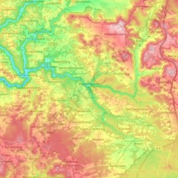
Name: Pottenstein topographic map, elevation, terrain.
Location: Pottenstein, Landkreis Bayreuth, Bavaria, 91278, Germany (49.70041 11.34736 49.83621 11.49116)
Average elevation: 1,545 ft
Minimum elevation: 1,043 ft
Maximum elevation: 2,018 ft
Make a donation
Gear up for your next adventure:
As an Amazon Associate, this site earns from qualifying purchases at no extra cost to you.
Other topographic maps
Click on a map to view its topography, its elevation and its terrain.
Drosendorf an der Aufseß
Germany > Bavaria > Landkreis Bayreuth > Hollfeld
Average elevation: 1,460 ft
Bad Berneck
Germany > Bavaria > Landkreis Bayreuth > Bad Berneck im Fichtelgebirge
Average elevation: 1,555 ft
Make a donation
Gear up for your next adventure:
As an Amazon Associate, this site earns from qualifying purchases at no extra cost to you.
Make a donation
Gear up for your next adventure:
As an Amazon Associate, this site earns from qualifying purchases at no extra cost to you.