
Thank you for supporting this site ❤️
Make a donation
Make a donation
Gear up for your next adventure:
As an Amazon Associate, this site earns from qualifying purchases at no extra cost to you.
Castro Laboreiro topographic map
Click on the map to display elevation.
Thank you for supporting this site ❤️
Make a donation
Make a donation
Gear up for your next adventure:
As an Amazon Associate, this site earns from qualifying purchases at no extra cost to you.
Castro Laboreiro
Curral do Gonçalo, na freguesia de Castro Laboreiro, fica situado a uma altitude de 1166 metros, tornado-se o 2º lugar habitado de mais elevada altitude em Portugal.
Thank you for supporting this site ❤️
Make a donation
Make a donation
Gear up for your next adventure:
As an Amazon Associate, this site earns from qualifying purchases at no extra cost to you.
About this map
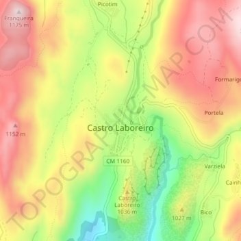
Name: Castro Laboreiro topographic map, elevation, terrain.
Average elevation: 3,261 ft
Minimum elevation: 2,556 ft
Maximum elevation: 3,829 ft
Thank you for supporting this site ❤️
Make a donation
Make a donation
Gear up for your next adventure:
As an Amazon Associate, this site earns from qualifying purchases at no extra cost to you.