
Make a donation
Gear up for your next adventure:
As an Amazon Associate, this site earns from qualifying purchases at no extra cost to you.
Domat/Ems topographic map
Click on the map to display elevation.
Make a donation
Gear up for your next adventure:
As an Amazon Associate, this site earns from qualifying purchases at no extra cost to you.
Domat/Ems
The Dreibündenstein (Romanish: Term bel) is a marker erected at the intersection of the Three Leagues (League of God's House, the League of the Ten Jurisdictions and the Grey League) which would found the modern canton of Graubünden. The stone is at an altitude of 2,160 m (7,090 ft) on the border between the municipalities of Domat/Ems, Scheid village (now part of Tomils municipality) and Malix. The original stone dates from 1722, and today is in the Rätian Museum in Chur. In 1742, Nicolin Sererhard mentions three stones. The Sektion Rhätia (Rhätian Section) of the Swiss Alpine club built this 2-metre (6 ft 7 in) tall stone marker in 1915. In 1970 a chair lift was added to mountain, making it easier to reach the marker.
Make a donation
Gear up for your next adventure:
As an Amazon Associate, this site earns from qualifying purchases at no extra cost to you.
About this map
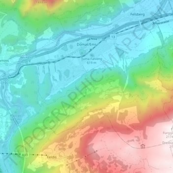
Name: Domat/Ems topographic map, elevation, terrain.
Location: Domat/Ems, Imboden, Grisons, 7013, Switzerland (46.79472 9.40616 46.84500 9.49747)
Average elevation: 3,501 ft
Minimum elevation: 1,841 ft
Maximum elevation: 7,129 ft
Make a donation
Gear up for your next adventure:
As an Amazon Associate, this site earns from qualifying purchases at no extra cost to you.