
Astepe topographic map
Interactive map
Click on the map to display elevation.
About this map
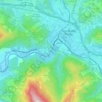
Name: Astepe topographic map, elevation, terrain.
Location: Astepe, Amorebieta-Echano, Vizcaya, País Vasco, 48340, España (43.19283 -2.76187 43.23283 -2.72187)
Average elevation: 509 ft
Minimum elevation: 174 ft
Maximum elevation: 1,558 ft
Other topographic maps
Click on a map to view its topography, its elevation and its terrain.
Leginetxe
España > País Vasco > Amorebieta-Echano > Leginetxe
Leginetxe, Amorebieta-Echano, Duranguesado, Vizcaya, País Vasco, 48340, España
Average elevation: 489 ft