
Thank you for supporting this site ❤️
Make a donation
Make a donation
Gear up for your next adventure:
As an Amazon Associate, this site earns from qualifying purchases at no extra cost to you.
Cuerno topographic map
Click on the map to display elevation.
Thank you for supporting this site ❤️
Make a donation
Make a donation
Gear up for your next adventure:
As an Amazon Associate, this site earns from qualifying purchases at no extra cost to you.
About this map
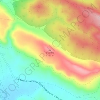
Name: Cuerno topographic map, elevation, terrain.
Location: Cuerno, Huerta de Rey, Burgos, Castiglia e León, 09430, Spagna (41.83435 -3.32332 41.83445 -3.32322)
Average elevation: 3,448 ft
Minimum elevation: 3,143 ft
Maximum elevation: 3,780 ft
Thank you for supporting this site ❤️
Make a donation
Make a donation
Gear up for your next adventure:
As an Amazon Associate, this site earns from qualifying purchases at no extra cost to you.