
Thank you for supporting this site ❤️
Make a donation
Make a donation
Gear up for your next adventure:
As an Amazon Associate, this site earns from qualifying purchases at no extra cost to you.
Veroli topographic map
Click on the map to display elevation.
Thank you for supporting this site ❤️
Make a donation
Make a donation
Gear up for your next adventure:
As an Amazon Associate, this site earns from qualifying purchases at no extra cost to you.
About this map
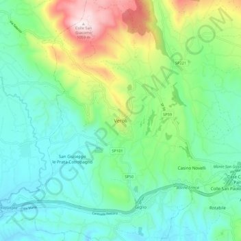
Name: Veroli topographic map, elevation, terrain.
Location: Veroli, Frosinone, Lazio, 03029, Italia (41.65127 13.37763 41.73127 13.45763)
Average elevation: 1,398 ft
Minimum elevation: 636 ft
Maximum elevation: 3,455 ft
Thank you for supporting this site ❤️
Make a donation
Make a donation
Gear up for your next adventure:
As an Amazon Associate, this site earns from qualifying purchases at no extra cost to you.