
Make a donation
Gear up for your next adventure:
As an Amazon Associate, this site earns from qualifying purchases at no extra cost to you.
Wattwil topographic map
Click on the map to display elevation.
Make a donation
Gear up for your next adventure:
As an Amazon Associate, this site earns from qualifying purchases at no extra cost to you.
About this map
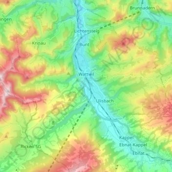
Name: Wattwil topographic map, elevation, terrain.
Location: Wattwil, Wahlkreis Toggenburg, St. Gallen, Switzerland (47.24968 9.02036 47.33864 9.15305)
Average elevation: 2,799 ft
Minimum elevation: 1,942 ft
Maximum elevation: 4,337 ft
Make a donation
Gear up for your next adventure:
As an Amazon Associate, this site earns from qualifying purchases at no extra cost to you.
Other topographic maps
Click on a map to view its topography, its elevation and its terrain.
Wildhaus
Switzerland > St. Gallen > Wahlkreis Toggenburg > Wildhaus-Alt St. Johann
Average elevation: 4,081 ft
Make a donation
Gear up for your next adventure:
As an Amazon Associate, this site earns from qualifying purchases at no extra cost to you.
Riet
Switzerland > St. Gallen > Wahlkreis Toggenburg > Bütschwil-Ganterschwil > Bütschwil
Average elevation: 2,254 ft