
Make a donation
Gear up for your next adventure:
As an Amazon Associate, this site earns from qualifying purchases at no extra cost to you.
Hilltop topographic map
Click on the map to display elevation.
Make a donation
Gear up for your next adventure:
As an Amazon Associate, this site earns from qualifying purchases at no extra cost to you.
About this map
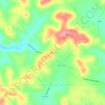
Name: Hilltop topographic map, elevation, terrain.
Location: Hilltop, Grayson County, Kentucky, United States (37.37505 -86.12719 37.41505 -86.08719)
Average elevation: 705 ft
Minimum elevation: 558 ft
Maximum elevation: 896 ft
Grayson County trails, hiking, mountain biking, running and outdoor activities
Make a donation
Gear up for your next adventure:
As an Amazon Associate, this site earns from qualifying purchases at no extra cost to you.
Other topographic maps
Click on a map to view its topography, its elevation and its terrain.
Rough River Lake
United States > Kentucky > Grayson County
As the seasons change, so does the size of the Rough River Lake. During the summer the lake is about 5,100 acres (2,100 ha), has 220 miles (350 km) of shoreline, is 39 miles long, and is 65 feet (20 m) deep in the deepest portion of the lake, which includes the area around the dam. During the winter the lake…
Average elevation: 600 ft
Make a donation
Gear up for your next adventure:
As an Amazon Associate, this site earns from qualifying purchases at no extra cost to you.