Geolocate

Ibb topographic map

Click on the map to display elevation.

Ibb

Ibb is located at an altitude of 2,050 metres (6,730 ft) on a spur of Mount Shamāḥī. Due to its high altitude, Ibb has a dry-winter humid subtropical climate (Köppen climate classification: Cwa), and is one of the wettest areas of Yemen, typically receiving around 500 mm of rain per annum.

Wikipedia (CC-BY-SA 3.0)

About this map

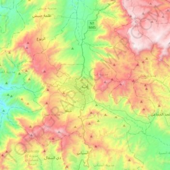
Name: Ibb topographic map, elevation, terrain.

Location: Ibb, Al Dhihar District, Ibb Governorate, Yemen (13.81016 44.01794 14.13016 44.33794)

Average elevation: 6,903 ft

Minimum elevation: 4,098 ft

Maximum elevation: 10,614 ft

Other topographic maps

Click on a map to view its topography, its elevation and its terrain.

Al Makhadir District

Yemen > Ibb Governorate

Average elevation: 6,631 ft

Dhi As Sufal District

Yemen > Ibb Governorate

Average elevation: 6,480 ft

Al Qafr District

Yemen > Ibb Governorate

Average elevation: 5,827 ft

Jiblah District

Yemen > Ibb Governorate

Average elevation: 6,962 ft

Gear up for your next adventure:

🧭Hiking Compass - Precision compass for reliable navigation in the wilderness
🎒Trail Energy Bars - High‑calorie bars for hiking energy
🚑Emergency Bivvies - Heat-reflective sleeping bags for survival situations
📱Heavy-Duty Phone Cases - Drop-proof and waterproof protection for outdoor navigation
🧤Tactile Hiking Gloves - Keep hands warm while operating GPS and smartphone screens

As an Amazon Associate, this site earns from qualifying purchases at no extra cost to you.