Geolocate

Riva topographic map

Click on the map to display elevation.

About this map

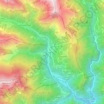
Name: Riva topographic map, elevation, terrain.

Location: Riva, Fobello, Vercelli, Piemonte, 13055, Italia (45.87904 8.13536 45.91904 8.17536)

Average elevation: 4,124 ft

Minimum elevation: 2,543 ft

Maximum elevation: 6,234 ft

Gear up for your next adventure:

🧭Outdoor Navigation Book - Learn advanced navigation skills
🧣Merino Neck Gaiters - Multi-functional headwear for wind and sun protection
🔥Fast-Boil Camping Stoves - Efficient cooking systems for quick trail meals
🔋Solar Power Banks - Keep your GPS and phone charged in remote wilderness areas
🪶Camping Sleeping Pad - Comfortable sleeping pad for backpacking

As an Amazon Associate, this site earns from qualifying purchases at no extra cost to you.