
Make a donation
Gear up for your next adventure:
As an Amazon Associate, this site earns from qualifying purchases at no extra cost to you.
Altenhellefeld topographic map
Click on the map to display elevation.
Make a donation
Gear up for your next adventure:
As an Amazon Associate, this site earns from qualifying purchases at no extra cost to you.
About this map
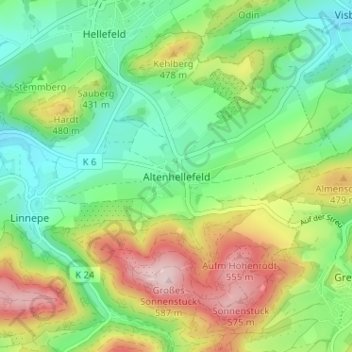
Name: Altenhellefeld topographic map, elevation, terrain.
Average elevation: 1,322 ft
Minimum elevation: 974 ft
Maximum elevation: 1,916 ft
Make a donation
Gear up for your next adventure:
As an Amazon Associate, this site earns from qualifying purchases at no extra cost to you.
Other topographic maps
Click on a map to view its topography, its elevation and its terrain.
Sorpesee
Deutschland > Nordrhein-Westfalen > Hochsauerlandkreis > Sundern > Stemel
Als Sperrbauwerk wurde erstmals in Nordrhein-Westfalen ein Staudamm mit Kerndichtung errichtet, die den Damm in einen wasserseitigen Dichtkörper und einen luftseitigen Stützkörper teilt. Die schlanke Kernmauer aus Beton zwischen Felssohle und Dammkrone stützt die davor liegende Lehmdichtung, die 1996 im…
Average elevation: 1,096 ft
Sorpesee - Vorbecken
Deutschland > Nordrhein-Westfalen > Hochsauerlandkreis > Sundern > Amecke > Bruchhausen
Average elevation: 1,073 ft
59846
Deutschland > Nordrhein-Westfalen > Hochsauerlandkreis > Sundern > Recklinghausen (Sauerland) > Selschede
Average elevation: 1,043 ft
Sorpetalsperre
Deutschland > Nordrhein-Westfalen > Hochsauerlandkreis > Sundern > Stemel
Average elevation: 948 ft
Make a donation
Gear up for your next adventure:
As an Amazon Associate, this site earns from qualifying purchases at no extra cost to you.