
Thank you for supporting this site ❤️
Make a donation
Make a donation
Gear up for your next adventure:
As an Amazon Associate, this site earns from qualifying purchases at no extra cost to you.
Lindrith topographic map
Click on the map to display elevation.
Thank you for supporting this site ❤️
Make a donation
Make a donation
Gear up for your next adventure:
As an Amazon Associate, this site earns from qualifying purchases at no extra cost to you.
About this map
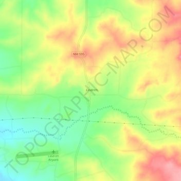
Name: Lindrith topographic map, elevation, terrain.
Location: Lindrith, Rio Arriba County, New Mexico, United States (36.28446 -107.06504 36.32446 -107.02504)
Average elevation: 7,254 ft
Minimum elevation: 7,077 ft
Maximum elevation: 7,431 ft
Thank you for supporting this site ❤️
Make a donation
Make a donation
Gear up for your next adventure:
As an Amazon Associate, this site earns from qualifying purchases at no extra cost to you.