Geolocate

Kanon topographic map

Click on the map to display elevation.

About this map

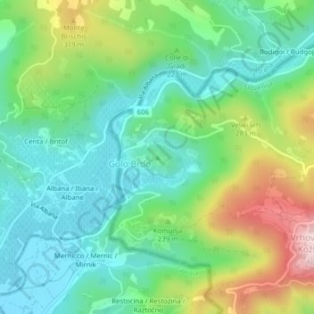
Name: Kanon topographic map, elevation, terrain.

Location: Kanon, Golo Brdo, Brda, Slovenia (46.05518 13.50206 46.05528 13.50216)

Average elevation: 646 ft

Minimum elevation: 295 ft

Maximum elevation: 1,414 ft

Gear up for your next adventure:

🌧️Backpack Rain Cover - Keep gear dry in wet weather
🕶️Glacier Sunglasses - Side shields to protect eyes from high-altitude snow glare
🦺Reflective Outdoor Gear - Safety gear for low‑light conditions
🏔️Mountain Trail Maps - High‑detail maps for popular peaks
🏕️Tent Footprint - Protect your tent base from wear

As an Amazon Associate, this site earns from qualifying purchases at no extra cost to you.