
Make a donation
Gear up for your next adventure:
As an Amazon Associate, this site earns from qualifying purchases at no extra cost to you.
Groton topographic map
Click on the map to display elevation.
Make a donation
Gear up for your next adventure:
As an Amazon Associate, this site earns from qualifying purchases at no extra cost to you.
About this map
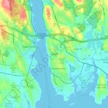
Name: Groton topographic map, elevation, terrain.
Location: Groton, New London County, Connecticut, 06340, United States (41.31016 -72.11620 41.39016 -72.03620)
Average elevation: 69 ft
Minimum elevation: -10 ft
Maximum elevation: 299 ft
New London County trails, hiking, mountain biking, running and outdoor activities
Make a donation
Gear up for your next adventure:
As an Amazon Associate, this site earns from qualifying purchases at no extra cost to you.
Other topographic maps
Click on a map to view its topography, its elevation and its terrain.
Groton Long Point
United States > Connecticut > New London County > Groton > Groton Long Point
Average elevation: 7 ft