
Make a donation
Gear up for your next adventure:
As an Amazon Associate, this site earns from qualifying purchases at no extra cost to you.
Babor topographic map
Click on the map to display elevation.
Make a donation
Gear up for your next adventure:
As an Amazon Associate, this site earns from qualifying purchases at no extra cost to you.
Babor
Le point culminant de la commune est le Mont Babor, au nord de la commune, à 2004 mètres d’altitude.
Make a donation
Gear up for your next adventure:
As an Amazon Associate, this site earns from qualifying purchases at no extra cost to you.
About this map
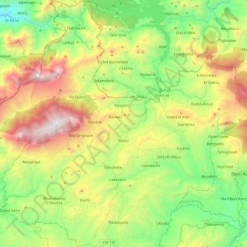
Name: Babor topographic map, elevation, terrain.
Location: Babor, Daïra Babor, Sétif, Algérie (36.40871 5.42249 36.59629 5.59811)
Average elevation: 3,074 ft
Minimum elevation: 810 ft
Maximum elevation: 6,535 ft
Make a donation
Gear up for your next adventure:
As an Amazon Associate, this site earns from qualifying purchases at no extra cost to you.
Other topographic maps
Click on a map to view its topography, its elevation and its terrain.