
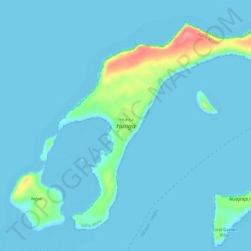
Hunga topographic map
Interactive map
Click on the map to display elevation.
About this map
Name: Hunga topographic map, elevation, terrain.
Location: Hunga, Vahe Motu, Vavaʻu, Tonga (-18.70801 -174.13368 -18.66828 -174.08314)
Average elevation: 26 ft
Minimum elevation: 0 ft
Maximum elevation: 276 ft
Other topographic maps
Click on a map to view its topography, its elevation and its terrain.
Keitahi
Tonga > Vavaʻu > Tu'anekivale
Keitahi, Tu'anekivale, Vahe Ha'alaufuli, Vavaʻu, Tonga
Average elevation: 39 ft
Fangatongo
Fangatongo, Neiafu, Vahe Neiafu, Vavaʻu, Tonga
Average elevation: 82 ft
Vavaʻu ʻUta
Vavaʻu ʻUta, Tefisi, Vahe Hihifo, Vavaʻu, Tonga
Average elevation: 69 ft