
Make a donation
Gear up for your next adventure:
As an Amazon Associate, this site earns from qualifying purchases at no extra cost to you.
Clearfield topographic map
Click on the map to display elevation.
Make a donation
Gear up for your next adventure:
As an Amazon Associate, this site earns from qualifying purchases at no extra cost to you.
Clearfield
Clearfield City has a total land area of 7.8 square miles (20 km2), and a population of 31,909 as of the 2020 Census, making it the fifth largest city in Davis County, behind Layton, Bountiful, Kaysville, and Syracuse. This creates a population density of 1498.1 people per square kilometer or 3860.5 people per square mile. Clearfield City has an average elevation of 4,327 feet (1,319 m) above sea level. The lowest point within the boundaries of the city is 4,314 feet (1,315 m) at the intersection of 1000 West and Antelope Drive on the city's western edge, and the highest is 4,711 feet (1,436 m) at a point that is within the city's northeast corner but physically located on Hill Air Force Base property along Constitution Way in their housing area. (AGRC)
Make a donation
Gear up for your next adventure:
As an Amazon Associate, this site earns from qualifying purchases at no extra cost to you.
About this map
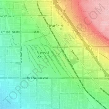
Name: Clearfield topographic map, elevation, terrain.
Location: Clearfield, Davis County, Utah, United States (41.07476 -112.05495 41.12536 -111.98717)
Average elevation: 4,455 ft
Minimum elevation: 4,265 ft
Maximum elevation: 4,790 ft
Davis County trails, hiking, mountain biking, running and outdoor activities
Make a donation
Gear up for your next adventure:
As an Amazon Associate, this site earns from qualifying purchases at no extra cost to you.
Other topographic maps
Click on a map to view its topography, its elevation and its terrain.
Antelope Island
United States > Utah > Davis County
The island is accessible via a 7-mile causeway from Syracuse in Davis County. Access from Interstate 15 is via exit 332, then west along Antelope Drive (SR-108). The island's shore (all but west side of the island) is mostly flat with beaches and plains to the base of the mountains on the island. These steep…
Average elevation: 4,285 ft
Make a donation
Gear up for your next adventure:
As an Amazon Associate, this site earns from qualifying purchases at no extra cost to you.
Make a donation
Gear up for your next adventure:
As an Amazon Associate, this site earns from qualifying purchases at no extra cost to you.
Mount Lebannon Acres
United States > Utah > Davis County > Centerville > Rosedale
Average elevation: 4,803 ft