Geolocate

Weld topographic map

Click on the map to display elevation.

About this map
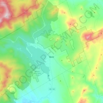
Name: Weld topographic map, elevation, terrain.

Location: Weld, Franklin County, Maine, 04285, United States (44.62723 -70.56380 44.78701 -70.34519)

Average elevation: 1,339 ft

Minimum elevation: 440 ft

Maximum elevation: 3,520 ft

Franklin County trails, hiking, mountain biking, running and outdoor activities

Other topographic maps

Click on a map to view its topography, its elevation and its terrain.

Webb Lake

United States > Maine > Franklin County > Weld

Average elevation: 810 ft

Gordon Hill

United States > Maine > Franklin County > Chesterville

Average elevation: 495 ft

Mount Blue

United States > Maine > Franklin County > Avon

Average elevation: 2,080 ft

Dryden

United States > Maine > Franklin County > Wilton

Average elevation: 541 ft

East Dixfield

United States > Maine > Franklin County > Wilton

Average elevation: 745 ft

East Wilton

United States > Maine > Franklin County > Wilton

Average elevation: 545 ft

Sandy River

United States > Maine > Franklin County > Madrid Township

Average elevation: 1,073 ft

Gear up for your next adventure:

🧥Men's Rain Shells - Premium waterproof and breathable jackets for mountain weather
🧷Carabiner Set - Durable clips for gear attachment
📷Action Camera - Capture your outdoor adventures in HD
🎒Hydration Pack - Hands‑free water reservoir for long hikes
🔪Outdoor Multitools - Essential survival tools for gear repair and field use

As an Amazon Associate, this site earns from qualifying purchases at no extra cost to you.