
Make a donation
Gear up for your next adventure:
As an Amazon Associate, this site earns from qualifying purchases at no extra cost to you.
Forksville topographic map
Click on the map to display elevation.
Make a donation
Gear up for your next adventure:
As an Amazon Associate, this site earns from qualifying purchases at no extra cost to you.
About this map
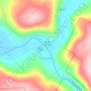
Name: Forksville topographic map, elevation, terrain.
Location: Forksville, Sullivan County, Pennsylvania, United States (41.47794 -76.61999 41.49976 -76.58077)
Average elevation: 1,437 ft
Minimum elevation: 965 ft
Maximum elevation: 1,932 ft
Sullivan County trails, hiking, mountain biking, running and outdoor activities
Make a donation
Gear up for your next adventure:
As an Amazon Associate, this site earns from qualifying purchases at no extra cost to you.
Other topographic maps
Click on a map to view its topography, its elevation and its terrain.
Muncy Valley
United States > Pennsylvania > Sullivan County > Davidson Township
Average elevation: 1,240 ft
Hillsgrove
United States > Pennsylvania > Sullivan County > Hillsgrove Township
Average elevation: 1,289 ft
Make a donation
Gear up for your next adventure:
As an Amazon Associate, this site earns from qualifying purchases at no extra cost to you.