
Thank you for supporting this site ❤️
Make a donation
Make a donation
Gear up for your next adventure:
As an Amazon Associate, this site earns from qualifying purchases at no extra cost to you.
Burren Junction topographic map
Click on the map to display elevation.
Thank you for supporting this site ❤️
Make a donation
Make a donation
Gear up for your next adventure:
As an Amazon Associate, this site earns from qualifying purchases at no extra cost to you.
About this map
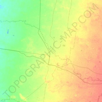
Name: Burren Junction topographic map, elevation, terrain.
Average elevation: 531 ft
Minimum elevation: 482 ft
Maximum elevation: 597 ft
Thank you for supporting this site ❤️
Make a donation
Make a donation
Gear up for your next adventure:
As an Amazon Associate, this site earns from qualifying purchases at no extra cost to you.
Other topographic maps
Click on a map to view its topography, its elevation and its terrain.
Lighting Ridge Hot Artesian Baths
Australia > New South Wales > Walgett Shire Council > Lightning Ridge
Average elevation: 489 ft
Lighting Ridge Hot Artesian Baths
Australia > New South Wales > Walgett Shire Council > Lightning Ridge
Average elevation: 489 ft