
Artigas topographic map
Interactive map
Click on the map to display elevation.
About this map
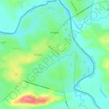
Name: Artigas topographic map, elevation, terrain.
Location: Artigas, 55000, Uruguay (-30.43044 -56.49842 -30.38491 -56.44471)
Average elevation: 364 ft
Minimum elevation: 282 ft
Maximum elevation: 568 ft
Other topographic maps
Click on a map to view its topography, its elevation and its terrain.
Bella Unión
Uruguay > Artigas > Bella Unión
Bella Unión, Artigas, 55100, Uruguay
Average elevation: 151 ft
Baltasar Brum
Uruguay > Artigas > Baltasar Brum
Baltasar Brum, Artigas, 55001, Uruguay
Average elevation: 456 ft
Javier de Viana
Uruguay > Artigas > Javier de Viana
Javier de Viana, Artigas, 55005, Uruguay
Average elevation: 348 ft
Tomás Gomensoro
Uruguay > Artigas > Tomás Gomensoro > Tomás Gomensoro
Tomás Gomensoro, Artigas, 55002, Uruguay
Average elevation: 299 ft