
Make a donation
Gear up for your next adventure:
As an Amazon Associate, this site earns from qualifying purchases at no extra cost to you.
Rimpfischhorn topographic map
Click on the map to display elevation.
Make a donation
Gear up for your next adventure:
As an Amazon Associate, this site earns from qualifying purchases at no extra cost to you.
Rimpfischhorn
Als grundsätzlich in Nord-Süd-Richtung ausgerichteter, steil aufragender Felskamm sendet das Rimpfischhorn einen Nordgrat, der im markanten Grossen Gendarm (4107 m) endet, zum Allalinpass (3552 m), eine Südostrippe zum Adlerpass (3786 m) und einen Westgrat zur Pfulwe (Rimpfischwäng-Grat). Westlich des Gipfels befindet sich auf rund 4000 m Höhe ein namenloser flacher Firnbuckel, der durch den Rimpfischsattel (3988 m) vom Hauptgipfel getrennt ist.
Make a donation
Gear up for your next adventure:
As an Amazon Associate, this site earns from qualifying purchases at no extra cost to you.
About this map
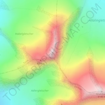
Name: Rimpfischhorn topographic map, elevation, terrain.
Location: Rimpfischhorn, Täsch, Visp, Wallis, 3929, Schweiz (46.02308 7.88391 46.02318 7.88401)
Average elevation: 11,909 ft
Minimum elevation: 10,528 ft
Maximum elevation: 13,720 ft
Make a donation
Gear up for your next adventure:
As an Amazon Associate, this site earns from qualifying purchases at no extra cost to you.