
South Tongu District topographic map
Interactive map
Click on the map to display elevation.
About this map
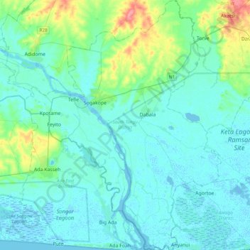
Name: South Tongu District topographic map, elevation, terrain.
Location: South Tongu District, Volta Region, Ghana (5.77443 0.48737 6.15473 0.78839)
Average elevation: 36 ft
Minimum elevation: -26 ft
Maximum elevation: 230 ft
Other topographic maps
Click on a map to view its topography, its elevation and its terrain.
Adaklu
Ghana > Volta Region > Adaklu District
Adaklu, Adaklu District, Volta Region, Ghana
Average elevation: 312 ft
Ho
Ghana > Volta Region > Ho Municipal District
Ho, Ho Municipal District, Volta Region, Ghana
Average elevation: 479 ft
North Tongu District
Ghana > Volta Region > North Tongu District
North Tongu District, Volta Region, Ghana
Average elevation: 115 ft
Saviefe Deme
Ghana > Volta Region > Ho West District
Saviefe Deme, Ho West District, Volta Region, Ghana
Average elevation: 860 ft
Battor
Ghana > Volta Region > North Tongu District > Battor
Battor, North Tongu District, Volta Region, Ghana
Average elevation: 23 ft
Akatsi
Ghana > Volta Region > Akatsi South District
Akatsi, Akatsi South District, Volta Region, Ghana
Average elevation: 125 ft