
Make a donation
Gear up for your next adventure:
As an Amazon Associate, this site earns from qualifying purchases at no extra cost to you.
Hülben topographic map
Click on the map to display elevation.
Make a donation
Gear up for your next adventure:
As an Amazon Associate, this site earns from qualifying purchases at no extra cost to you.
Hülben
The Hülben stalactite cave was discovered during the construction of national road Bad Urach-Hülben on September 19, 1978, it is a stalactite cave with stalactites and stalagmites. An about 5 m deep shaft leads into the easily accessible part of the cave. This has about room size, but with only partial low altitude.
Make a donation
Gear up for your next adventure:
As an Amazon Associate, this site earns from qualifying purchases at no extra cost to you.
About this map
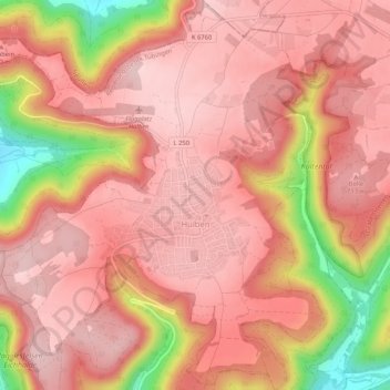
Name: Hülben topographic map, elevation, terrain.
Average elevation: 2,188 ft
Minimum elevation: 1,594 ft
Maximum elevation: 2,405 ft
Make a donation
Gear up for your next adventure:
As an Amazon Associate, this site earns from qualifying purchases at no extra cost to you.
Other topographic maps
Click on a map to view its topography, its elevation and its terrain.
Kleinengstingen
Germany > Baden-Württemberg > Landkreis Reutlingen > Kleinengstingen
Average elevation: 2,395 ft
Engstingen
Germany > Baden-Württemberg > Landkreis Reutlingen
Engstingen is located on the northern edge of the Swabian Jura, at 680–750 metres (2,230–2,460 ft) altitude on the Alb plateau near the Alb edge in the valley of Ur-Lauter, about 15 km south of the town Reutlingen.
Average elevation: 2,421 ft
Make a donation
Gear up for your next adventure:
As an Amazon Associate, this site earns from qualifying purchases at no extra cost to you.