Geolocate

Lod topographic map

Click on the map to display elevation.

About this map

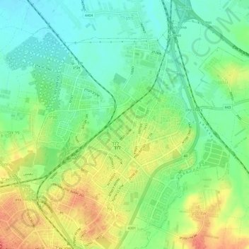
Name: Lod topographic map, elevation, terrain.

Location: Lod, Ramla Subdistrict, Center District, 7147308, Israel (31.93243 34.86123 31.97477 34.92107)

Average elevation: 194 ft

Minimum elevation: 118 ft

Maximum elevation: 295 ft

Other topographic maps

Click on a map to view its topography, its elevation and its terrain.

Zur Izhak

Israel > Center District

Average elevation: 276 ft

Kfar Saba

Israel > Center District

Average elevation: 177 ft

Lod

Israel > Center District

Average elevation: 200 ft

Tnuvot

Israel > Center District > Tnuvot

Average elevation: 128 ft

Hulda

Israel > Center District > Gezer Regional Council

Average elevation: 384 ft

Gear up for your next adventure:

🪑Ultralight Camp Chairs - Portable seating for resting after a long day of mapping
🧭Hiking Compass - Precision compass for reliable navigation in the wilderness
💧Water Filtration Bottles - Safely drink from streams and lakes while exploring
📱Heavy-Duty Phone Cases - Drop-proof and waterproof protection for outdoor navigation
Camping Coffee Makers - Enjoy premium coffee at the summit or campsite

As an Amazon Associate, this site earns from qualifying purchases at no extra cost to you.