Geolocate

Highfields Park topographic map

Click on the map to display elevation.

About this map

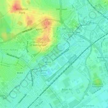
Name: Highfields Park topographic map, elevation, terrain.

Location: Highfields Park, Dunkirk, Nottingham, England, United Kingdom (52.93259 -1.20263 52.93959 -1.18760)

Average elevation: 115 ft

Minimum elevation: 62 ft

Maximum elevation: 236 ft

Other topographic maps

Click on a map to view its topography, its elevation and its terrain.

Wollaton

United Kingdom > England > Nottingham

Average elevation: 190 ft

Wilford

United Kingdom > England > Nottingham

Average elevation: 92 ft

Wollaton

United Kingdom > England > Nottingham

Average elevation: 190 ft

Bulwell

United Kingdom > England > Nottingham

Average elevation: 276 ft

Bulwell

United Kingdom > England > Nottingham

Average elevation: 276 ft

Bulwell

United Kingdom > England > Nottingham

Average elevation: 276 ft

Bulwell

United Kingdom > England > Nottingham

Average elevation: 276 ft

Berridge Ward

United Kingdom > England > Nottingham > Arnold

Average elevation: 184 ft

Gear up for your next adventure:

📱Heavy-Duty Phone Cases - Drop-proof and waterproof protection for outdoor navigation
🚑Emergency Bivvies - Heat-reflective sleeping bags for survival situations
☀️Outdoor Sunscreen - High protection sunscreen for outdoor activities
🧥Men's Rain Shells - Premium waterproof and breathable jackets for mountain weather
🧭GPS Watch Accessories - Bands and chargers for GPS watches

As an Amazon Associate, this site earns from qualifying purchases at no extra cost to you.