Geolocate

Engenberg topographic map

Click on the map to display elevation.

Engenberg

Der Ortsname stammt vom Personen(kurz)namen Enge oder Ëmmo und bedeutet somit (Siedlung an) der Anhöhe des Enge/Ëmmo.

Wikipedia (CC-BY-SA 3.0)

About this map

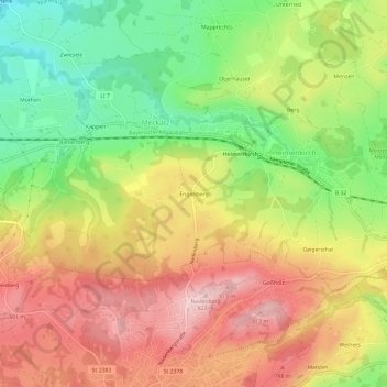
Name: Engenberg topographic map, elevation, terrain.

Location: Engenberg, Meckatz, Heimenkirch, Landkreis Lindau, Bayern, 88178, Deutschland (47.60407 9.87488 47.64407 9.91488)

Average elevation: 2,316 ft

Minimum elevation: 1,913 ft

Maximum elevation: 2,694 ft

Gear up for your next adventure:

🚗GPS Dash Cams - Record your scenic drives through mountain passes and canyons
📚Navigation Handbooks - Master the art of reading topographic maps and using a compass
📌Outdoor GPS Map App - Apps and devices for digital topographic navigation
🪶Fire Starter Kit - Reliable fire starter for survival and camping
🎒Day Hiking Backpack - Lightweight backpack perfect for day trips and outdoor adventures

As an Amazon Associate, this site earns from qualifying purchases at no extra cost to you.