Geolocate

Etlan topographic map

Click on the map to display elevation.

About this map

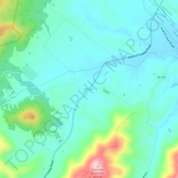
Name: Etlan topographic map, elevation, terrain.

Location: Etlan, Madison County, Virginia, 22719, United States (38.50555 -78.28238 38.54555 -78.24238)

Average elevation: 755 ft

Minimum elevation: 577 ft

Maximum elevation: 1,398 ft

Madison County trails, hiking, mountain biking, running and outdoor activities

Other topographic maps

Click on a map to view its topography, its elevation and its terrain.

Rapidan River

United States > Virginia > Madison County

Average elevation: 410 ft

Gear up for your next adventure:

🧤Hiking Gloves - Protective gloves for rugged trails
🧭Map Reading Tools - Tools and kits for map navigation
🔭Compact Binoculars - HD vision for scouting terrain and identifying distant landmarks
🗻Climbing Gear Basics - Essential gear for beginner climbers
📚USA Hiking Guide Books - Top trail guides and map books

As an Amazon Associate, this site earns from qualifying purchases at no extra cost to you.