
Make a donation
Gear up for your next adventure:
As an Amazon Associate, this site earns from qualifying purchases at no extra cost to you.
Brenken topographic map
Click on the map to display elevation.
Make a donation
Gear up for your next adventure:
As an Amazon Associate, this site earns from qualifying purchases at no extra cost to you.
Brenken
Brenken liegt im Tal der Alme auf einer Höhe von etwa 220 Metern über NN zwischen der Stadt Büren und dem Ortsteil Ahden. Die Kernstadt Büren befindet sich vier Kilometer südwestlich, Geseke acht Kilometer nordwestlich und die nächste Großstadt Paderborn 18 Kilometer nordöstlich (alle Angaben in Luftlinie).
Make a donation
Gear up for your next adventure:
As an Amazon Associate, this site earns from qualifying purchases at no extra cost to you.
About this map
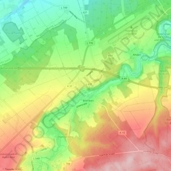
Name: Brenken topographic map, elevation, terrain.
Average elevation: 784 ft
Minimum elevation: 440 ft
Maximum elevation: 1,214 ft
Make a donation
Gear up for your next adventure:
As an Amazon Associate, this site earns from qualifying purchases at no extra cost to you.