
Make a donation
Gear up for your next adventure:
As an Amazon Associate, this site earns from qualifying purchases at no extra cost to you.
Handwara topographic map
Click on the map to display elevation.
Make a donation
Gear up for your next adventure:
As an Amazon Associate, this site earns from qualifying purchases at no extra cost to you.
Handwara
Handwara is located at 34°24′N 74°17′E / 34.40°N 74.28°E / 34.40; 74.28 at an average elevation of 1,582 metres (5,190 feet) above sea level. The region boasts breathtaking natural beauty, with the Pohru River (locally called 'Talri river')—a tributary of the Jhelum—flowing through the town.
Make a donation
Gear up for your next adventure:
As an Amazon Associate, this site earns from qualifying purchases at no extra cost to you.
About this map
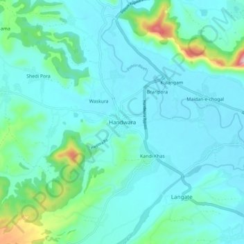
Name: Handwara topographic map, elevation, terrain.
Average elevation: 5,374 ft
Minimum elevation: 5,203 ft
Maximum elevation: 6,335 ft
Make a donation
Gear up for your next adventure:
As an Amazon Associate, this site earns from qualifying purchases at no extra cost to you.